1,500
miles during our 8 day trip during May 2008 to the Yorkshire Dales
The trip up is 330 miles, so quite a long day, we arrived at Beck Hall
at about 5.30pm, booked in, had a cupper, a shower, and relaxed, later we
enjoyed a meal at the hotel (they do dinner on Fridays, Saturdays and Sundays)
After breakfast which was the normal blow out, off we set to visit the area,
this remained the pattern for the eight days we were there, although we did
try the pubs in the village for dinner. Our daily mileage was around 115 and
included a day visit to the Lake District. This area of England is renowned
for rain and rapidly changing weather, we were so fortunate as we had a completely
dry 7 days, the trip back is best forgotten, and I think the rain had saved
itself for our return journey. I could now go into our day by day visits and
rides, which would be lengthy, so instead I am going to highlight a few areas
and places not to be missed if you are ever in the area.
This
year a smaller number than normal came with us to the Dales as accommodation
in the Dales is mostly small B&B's with just a few rooms, so it was difficult
to find somewhere for larger numbers, also, as we found last year, riding
the Lakes, Peak District and Dales can be very challenging, which does not
suit everyone.
To sum up our 8 day visit I will use the words of Angie "It's
like riding through a postcard" in fact there were a couple
of days where our route only passed a few tiny hamlets, no villages or towns
simply because there are so few.
In my own view I think the area of the Dales can be described as The
Lakes, The Peak District and Scotland all rolled into one, lush valleys,
forest areas, steep twisting lanes and barren hill tops, all go to make up
somewhere truly special.
ALWAYS
HAVE AN ORDANCE SURVEY MAP WITH YOU
You will notice Red Dotted
Lines which are National Cycle Routes, and
Blue Dotted Lines which are Regional Routes,
both of which are fine for motorcyclists, they are normally
the most scenic routes to be found in the area you are visiting.
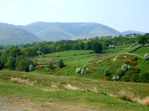
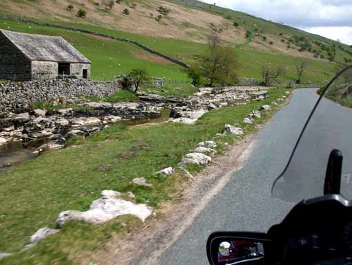
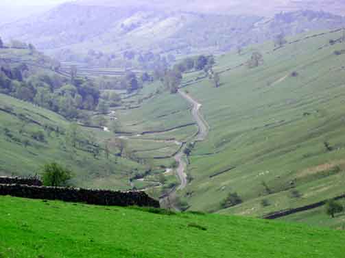
The Yorkshire Dales
The Yorkshire Dales National Park has outstanding scenery, a range of wildlife
habitats and a rich cultural heritage. It's a special place - a fantastic
outdoor arena for recreation and peaceful relaxation and a haven for wildlife.
Covering an area of 1,762 square kilometers (680 square miles), the National
Park is located in the north of England, and straddles the central Pennines
in the counties of North Yorkshire and Cumbria. www.yorkshiredales.org.uk
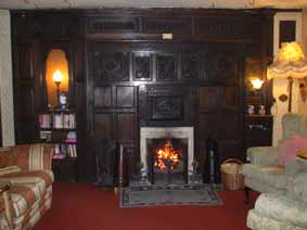
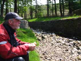
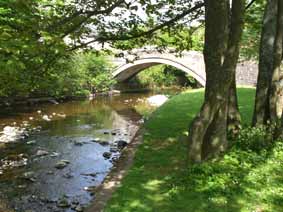
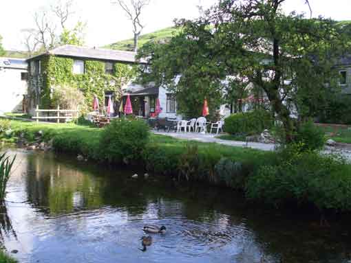
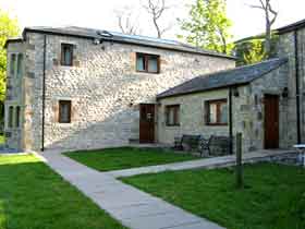
Beck
Hall at Malham.
Boasting a charming stream-side setting, rustic log-fires and home-cooked
food, this elegant 18th century building is an ideal retreat for both business
and leisure travellers.
Beck Hall has 17 ensuite bedrooms, all of which offer Wi-Fi connection, and
some which contain four-posters beds. The hotel is located in the centre of
the Yorkshire Dales National Park, where you can enjoy long and scenic strolls
during the day. With 2 pubs nearby and the hotel's own café for residents,
plus an alcohol licence, you will find plenty to eat and drink. www.beckhallmalham.com
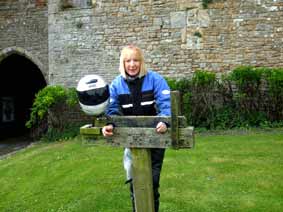
Steve
had a room in the new block complete with a steam power shower, having turned
on full power to warm it up, he phoned home, next thing we knew was the fire
alarm went off and we all had to vacate the hotel.
What
made things worst was the fact Michel had just settled down to read the Daily
Mail, a paper which in his view is rubbish, nice to know he is now an avid reader.
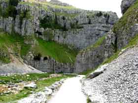
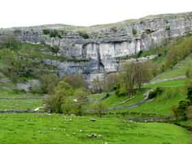
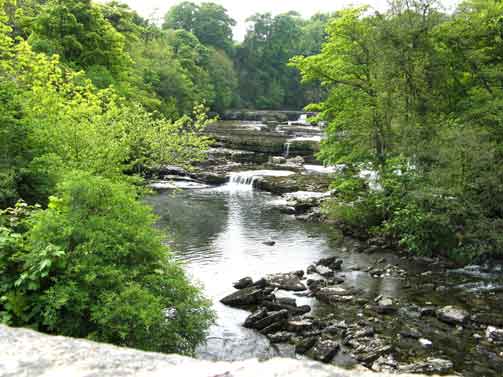
Malham
Cove
Standing some 80 metres high and 300 metres wide and north of the mid craven
fault, Malham Cove is a curved crag of carboniferous limestone formed after
the last ice age. Meltwater, particularly from Malham Tarn, cut back the cove
as it fell over the edge as a waterfall. This erosion took place more actively
at the lip of the fall rather than at the sides, hence the curved shape. Water
(in reduced amounts after the ice age) easily finds it way down through the
many joints and fissures of the limestone and thus the saturation level never
rises high enough to make Malham Cove the waterfall that it once was, although
there have been reports of water flowing over the cove after heavy rainfalls
in the early 19th century.
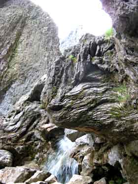
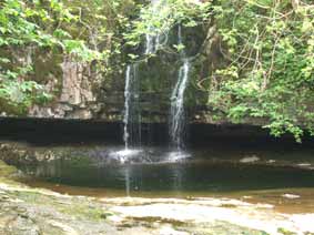
Gordale Scar-
To the north of the Mid Craven Fault in the Malham Formation is Gordale Scar,
which was carved as a melt water channel beneath the Devensian icesheet. The
sides of this gorge overhang to a considerable extent, suggesting that there
was once a great cavern, the roof of which has subsequently collapsed.
On close observation remnants of this roof can been found to the right above
the first waterfall. The left side of the cavern is noticeable for its close
and intimate vertical jointing dividing the limestone into thin plates sometimes
less than an inch in thickness.
The
waterfalls flow over large masses of tufa, more of which can be found further
downstream at a short
distance south of
the scar.
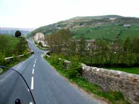
NOT
TO BE MISSED
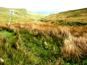
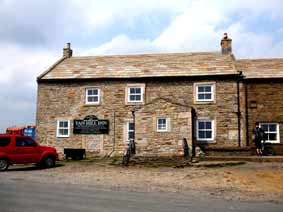
B6270 which runs from Down Holme - Nateby through the Swaledale Valley,
branch off at Keld to The Tan Hill Inn (highest Inn in England (1762') as we
did for lunch, it was quite strange to eat lunch watching lambs being
bottle fed in the bar. Our route was from *Castle Bolton to Grinton
to join the B6270, which is a small road over Redmire Moor (565') with truly
amazing views across the Swaledale Valley.
The B6270 is a very pretty and varied road with great views to the left
and right- a must if you are in the area.
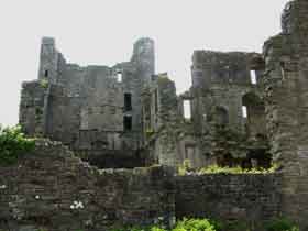
*Bolton Castle is a massive 14th century stone quadrangular fortress,
founded by Richard le Scrope. The high east curtain wall, contains the gatehouse
and its vaulted passage, is the only medieval entrance to this palatial castle.
The large rectangular courtyard, is surrounded by an impressive range of lodgings,
three storeys high and only five identical doorways gave access, each protected
by a portcullis. Huge five storey residential towers flank the angles, with
flanking turrets on the north and south curtain walls but sadly following Civil
War slighting, the Kitchen Tower collapsed in 1761.
The recent history of Tan Hill.
In 1085, when William the Conqueror's surveyors where compiling the Doomsday
Book, they wrote the area above Reeth off as "wasteland". Records
of Tan Hill's early days are sketchy at best although mining for coal had started
by the 12th Century. It is possible that the Romans mined coal during their
occupation of England and Wales in the first four centuries A.D.
1586 William Camden in his guide book, 'Britannia' notes a solitary inn.
The current inn dates from the 17th Century
12th to 20th Centuries Mining for coal on Tan Hill dates from at least the
12th Century A.D. and possibly earlier. The coal was a poor quality crow coal
which gave off a lot of soot when burnt. It was not suitable for the steam engines
that were to arrive in the Industrial Revolution - the superior coal from the
County Durham pits was used instead to fuel the trains on the Stockton and Darlington
Railway.
The inn was not on its own all the time. Miners' cottages stood near the inn
until they were demolished with the closure of the mines in the early 20th Century.
1903 Susan Peacock's Legacy: Born in West Witton in Wensleydale, Susan
Peacock worked in various domestic jobs before marrying Richard Parrington of
the Cat Hole Inn in Keld. The couple took over the Tan Hill Inn in 1903 which
by then was in a bad state of repair. They made a success of the inn despite
the waning mining industry. Richard Parrington died, leaving Susan to bring
up her three daughters, Olive, Edna and Maggie. She married Michael Peacock,
an Arkengarthdale native and owner of one of the Tan Hill pits, acquiring the
Peacock name which is familiar to all those who come to Tan Hill.
While
we were there we found by chance The Forest of Bowland
which is just to the left of the Dales, and can be summed up as follows:
Bowland is essentially upland country forming part of the Pennines, sharing
many of the characteristics of other upland areas like the Peak District and
Yorkshire Dales National Park but its essential landscape character is one of
grandeur and isolation. The area is dominated by a central upland core of deeply
incised gritstone fells with summits above 450m and vast tracts of heather-covered
peat moorland.
The fells' fringe of foothills is dissected by steep-sided valleys which open
out into the rich green lowlands of the Ribble, Hodder, Wyre and Lune Valleys.
Well-wooded and dotted with picturesque stone farms and villages, these lower
slopes, criss-crossed by dry stone walls, contrast with and complement the dramatic
open sweep of the gritstone heights. On its south-eastern edge, famous Pendle
Hill forms the outlier of the Forest of Bowland.
The combination of 'wild' expanses of open moorland and estate landscapes on
the moorland fringe together with the transitional landscapes to the lower lying
river valleys gives this area a distinctive quality of its own. The cloughs,
steep sided and wooded valleys, provide a strong link between the upland and
lowland landscapes.
Bowland's ecological features make it a nationally important area for nature
conservation and 13 per cent is designated as Sites of Special Scientific Interest.
The moors are a major breeding ground for upland birds and the major part of
the Bowland Fells is designated as a Special Protection Area under the European
Birds Directive. The lowlands contain important ancient woodland habitat.
Building in Bowland uses local gritstone and has a strong vernacular style which
adds to the quality of the landscape. The AONB is sparsely populated with over
three-quarters living in villages, and the remainder in loosely-knit hamlets
or isolated dwellings in open countryside. Traditional villages such as Slaidburn,
Downham and Newton have seen very little modern development.
The
wireless became a novelty at the inn in 1930 and Susan Peacock would often take
part in radio broadcasts, telling people of the quiet life. This led to hundreds
of people visiting the inn out of curiosity.
1917 During the First World War, pub opening was restricted to lunchtimes
and evenings only to stop people from getting drunk during the war effort. These
laws will change little for the next seventy years.
1990 Construction of extension providing the inn with seven new en-suite
rooms along with new toilets, pool room and flat.
1995 In 1995, the inn was the first pub to obtain a licence to hold wedding
ceremonies under new laws that allow people to marry in places other than a
church or registry office. Tan Hill Inn no longer retains its licence to host
weddings but still hosts many Stag, Hen and reception parties.
2005 Landlords Margaret and Alex Baines finally hang up their Bar Towels
after 20 years service at Tan Hill. The new owners Mike and Tracy are looking
forward to the challenge of running this unique and very special place. Tan
Hill Inn's unique place in the United Kingdom and in history should hopefully
guarantee its future at a time when many rural pubs are facing closure. It's
fame has led to the Inn featuring in a couple of television adverts, one for
double glazing and the other for mobile telephones. The Inn has been visited
by several celebrities of the day and created a few personalities itself.
NOT
TO BE MISSED
Another route is Butter Tubs Pass (676') from Thwaite on the B6270 to Hawes,
ride it if you dare.
NOT
TO BE MISSED
A648 from Wensley - Sedbergh a very pretty road with gentle bends through
the Wensley Dale Valley, have a look at Aysgarth Falls when you are passing.
Aysgarth is perhaps best known for its breathtaking triple flight of waterfalls,
carved out by the River Ure on its descent to mid-Wensleydale. The Upper Fall
featured in the film Robin Hood, Prince of Thieves. There is car parking at
the Yorkshire Dales National park Information Centre and other parking on
the south of the river. Park here and enjoy one of the well-signposted walks
which wind through the wooded gorge, offering spectacular views (and photo
opportunities) of the river and falls. The area is carpeted in wild flowers
in the Spring and Summer, and wild birds, squirrels and deer can often be
glimpsed amongst the trees.
NOT
TO BE MISSED
The Forest of Bowland just to the left of the Dales. This enchanting area
must not be missed, it can be accessed at Long Preston (on A65). Join the
B6478, at Newton take a small road to Dunsop Bridge (stop at Puddelducks Café
as we did) - Sykes - Marshaw and then turn and reverse the route, you will
not be disappointed. If you have time at Slaidburn take a small road on your
right to High Benton, after about 11 miles turn right towards Keasden and
right again, bringing you back to the B6478, you will rise to (1786') and
down again.
NOT
TO BE MISSED
Coverdale B6161 Skipton - West Burton, a great road to visit, but as you join
the A684 turn right to Wesley, then right again towards Carlton and on to
Kettlewell and Grassington, this route is not for the faint hearted, as this,
as are many of the small roads, in the Dales, challenging to motorcyclists,
but so rewarding.
NOT TO BE MISSED
Malham - Settle from Malham take the small road past Malham Cove to Settle,
it rises through Kirby Fell (1815') and has some truly amazing views from
the top, also you will notice the wind picks-up and the temperature drops
due to the altitude. It is worth taking a right fork while you are up there
to Arncliff and Kilnesy on the B6160, the height (600') and wildness of this
small road has to be experienced.
NOT TO BE MISSED
B6265 join it off the A61, north of Harrogate, it runs through Summer Bridge
- Pateley Bridge - Grassington - Kettlewell - Buckden and West Burton- another
great ride during our visit.
NOT TO BE MISSED
THE LAKES- they are only 30 miles away along the fabulous A65, it is worth
the ride over, although a visit can only take in a small part of the Lakes.
Head for Ambleside just north of Windermere. In Ambleside take the A591 and
then take the turning on your right (signposted) to Kirkstone Pass which joins
the A592 to Ullswater Lake. This will give you just a taste as to why the
Lake District is my favorite part of the United Kingdom
NOT TO BE MISSED
A686- while you are in the area and if you have time, join the A686 at Penrith,
and ride to Alston Moor and on to Haydon Bridge, this is one of the UK's top
10 biker's roads. Visit the café on top of Alston Moor and enjoy the
360 degree views across the Moors.
Paul Fareham (Photos by Angie and Steve)